Homebriefing system

Since the introduction in 2017, the homebriefing system has been continuously developed and improved.


General Information:

  • The service, which is free of charge, can be used for domestic flights in Austria, and for subsequent flight plans for international flights taking off from the country.
  • The system will operate on the basis of the European AIM database (EAD), making it significantly more cost effective.
     
  • Our homebriefing system has been successfully tested with the following browsers: Microsoft Edge (Windows), Mozilla Firefox 78 (Windows), Google Chrome 90 (Windows), Apple Safari 14 (Apple). The use of different browsers can result in reduced functionalities.
     

Please find below all the relevant information regarding the new functionalities with the latest release:

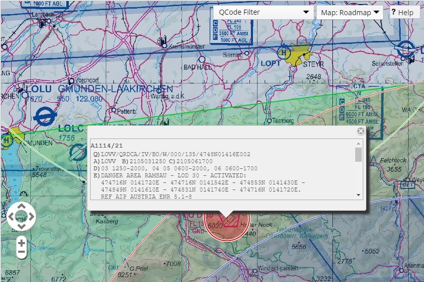
  • New background maps can be selected in the briefing and aviation data can be displayed on the map (ICAO 1: 500000, GAFOR, ...)
  • New briefing options which can be saved - "Charts / Maps" includes all the maps available in the system (visual flight map, airport maps, ...) to the briefing.
  • Newly adapted help - also in the mobile version
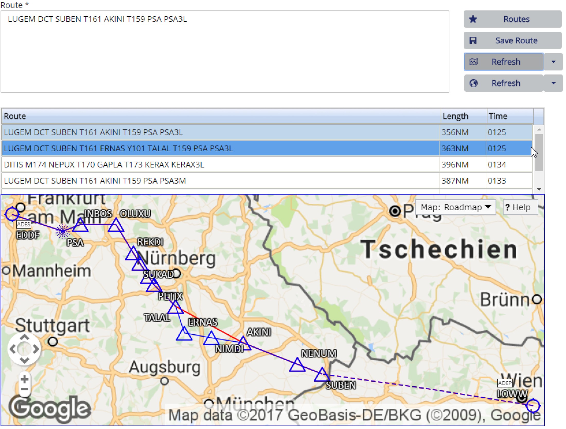
  • New route proposals through user routes also for Y / Z flight plans
  • NM slot messages are resolved - the reason of the slot message is displayed
  • The rejection reason for flight plans is displayed in the flight plan overview - suggested routes can be adopted directly 
  • Mark NOTAM as "read" - You can permanently mark NOTAM as read in order to keep the printed briefing compact
  • Numerous fixed errors and adjustments in the area of ​​usability


New functionalities:

  • Working in collaboration with Austrian pilots, Austro Control has reworked the system with the specific aim of enhancing user friendliness. Operation, navigation and layout were redesigned in a number of trial runs with our technology partners, in order to make flight preparations quicker and more straightforward.
     
  • Following numerous requests from users, a mobile version of homebriefing is now also available. Quick and easy use of the most important basic functions is a priority, and this service will be continuously optimised. However, full functionality is only available in the desktop version.
:
  • The new flight plan wizard, which is aimed at trainee and amateur pilots, guides users through each stage of the flight plan submission process.
     
  • Airports and FIRs can now be selected using Google Maps in the course of submitting flight plans.
     
  • Flight paths can now also be displayed in Google Maps.
     
  • The function for creating flight plan templates has been enhanced.
     
  • A list of aircraft types is provided, and the relevant type can be selected directly from the list. This means it is no longer necessary to be familiar with all aircraft abbreviations.
     
  • A new form of briefing has been developed specifically for VFR pilots. The geographical area in which the flight will take place can be marked in Google Maps, and the system then only displays the NOTAMs for this particular region. As a result, users have far fewer NOTAMs to read. The briefing is displayed graphically and in .pdf format, meaning it is significantly shorter and clearer.


:
Additional information on weather conditions in Austria and neighbouring countries can be accessed via a link in the homebriefing system. The link from homebriefing means that a separate login for the Austro Control aviation weather site is no longer needed.  However, homebriefing access does not enable you to access the aviation weather site outside the homebriefing system. In this case, a separate account is needed.

The aviation weather site provides users with a comprehensive range of weather forecasts and warnings which is familiar from the previous homebriefing version (satellite images for the different ICAO regions, global significant weather charts, etc.), as well as a number of new functions:

  • Weather radar data: improved and more precise resolution, with zoom and animation options.
     
  • New satellite images for Europe and Central Europe produced using RGB image processing technology for improved differentiation between high, low and compact cloud, and between low cloud cover (fog, low stratus and stratocumulus) and snow cover in winter.
     
  • ALDIS lightning data in near real time. 
     
  • Weather conditions: a product developed by the Central Institute of Meteorology and Geodynamics (ZAMG) that combines up-to-date satellite images (max. six hours old) with analysis of ground pressure and weather fronts.
     
  • Meteorogram: For the grid points of Austria’s six international airports: a product for users with an interest in meteorology, which produces models for 72-hour periods.
     
  • Ground pressure/precipitation maps: model data on changes in the ground pressure field and any areas of precipitation over a 72-hour period.
     
  • Information pages: all products include brief descriptions of their basic functions. Detailed descriptions of complex weather products are available by clicking on a link.
All aviation weather information relevant for flights under VFR or IFR can be found in the Motorised flight section of the site.

:

Contact

www.homebriefing.com

If you have any questions about the system, please feel free to contact us.

Helpdesk +43 5 1703 3211

.